![](/images/other/stat-length.png)
![Randonnée Marche La Plagne-Tarentaise - Boucle de Carolley au départ de Plagne Soleil - Photo](https://media.geolcdn.com/t/1900/400/ext.pjpeg?maxdim=2&url=https%3A%2F%2Fservices.sitytrail.com%2FGeolivesWS%2FDownloadMedia.ashx%3FTrailID%3D604619%26Media%3Dfix__20160726133003.jpg)
Boucle de Carolley au départ de Plagne Soleil
fredmig67
Utilisateur
![Longueur](/images/other/stat-length.png)
![Altitude max](https://static1.geolcdn.com/siteimages/upload/files/1508320355ic_sort_altitude_max_24dp.png)
![Dénivelé positif](https://static1.geolcdn.com/siteimages/upload/files/1508320355ic_sort_den_pos_24dp.png)
![Km-Effort](/images/other/stat-length.png)
![Altitude min](https://static1.geolcdn.com/siteimages/upload/files/1508320355ic_sort_altitude_min_24dp.png)
![Dénivelé négatif](https://static1.geolcdn.com/siteimages/upload/files/1508320355ic_sort_den_neg_24dp.png)
![Boucle](https://static1.geolcdn.com/siteimages/upload/files/16400158638029165_repeat_loop_refresh_sync_direction_icon.png)
![Marche](https://static1.geolcdn.com/sitytour/trail-icons/101.png)
4h18
Difficulté : Moyen
![Scannez ce code QR pour ouvrir la randonnée dans l'application SityTrail](https://capi.geolives.com/qq0zvz2zws4bq2lad0pu/sitytour/trails/604619/qr.png?size=200)
Application GPS de randonnée GRATUITE
À propos
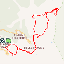
Randonnée Marche de 14 km à découvrir à Auvergne-Rhône-Alpes, Savoie, La Plagne-Tarentaise. Cette randonnée est proposée par fredmig67.
Description
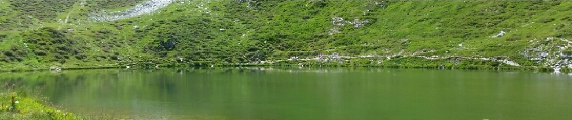
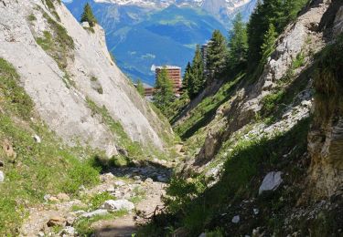
Au départ de Plagne Soleil, arrêt navette devant les résidences CGH, prendre la direction de Belle Plagne en passant par le Dou du Praz. Arrivé à Belle Plagne, prendre la piste "col de l'Arpette. Au col de l'Arpette, redescendre sur le col de Carolley et accéder au lac de Carolley. Retour au col de l'Arpette et retour à Belle Plagne par la piste partant à droite.
Localisation
Commentaires
Randonnées à proximité
![Randonnée A pied Aime-la-Plagne - Le Mont Jovet - Photo](https://media.geolcdn.com/t/375/260/e03d3a37-c792-4b26-aee8-eb362e80dc2f.jpeg&format=jpg&maxdim=2)
![A pied A pied](https://static1.geolcdn.com/sitytour/trail-icons/100.png)
A pied
![](/images/other/stat-length.png)
![](https://static1.geolcdn.com/siteimages/upload/files/16400158638029165_repeat_loop_refresh_sync_direction_icon.png)
![Randonnée A pied La Plagne-Tarentaise - Les Frasses - Photo](https://media.geolcdn.com/t/375/260/57e5726a-4c56-4000-a6b5-c37a4dc312d4.jpeg&format=jpg&maxdim=2)
![A pied A pied](https://static1.geolcdn.com/sitytour/trail-icons/100.png)
A pied
![](/images/other/stat-length.png)
![](https://static1.geolcdn.com/siteimages/upload/files/16400158638029165_repeat_loop_refresh_sync_direction_icon.png)
![Randonnée A pied La Plagne-Tarentaise - Boucle du Carroley - Photo](https://media.geolcdn.com/t/375/260/3845229a-3558-42f8-bdc8-ddfb57759bc2.jpeg&format=jpg&maxdim=2)
![A pied A pied](https://static1.geolcdn.com/sitytour/trail-icons/100.png)
A pied
![](/images/other/stat-length.png)
![](https://static1.geolcdn.com/siteimages/upload/files/16400158638029165_repeat_loop_refresh_sync_direction_icon.png)
![Randonnée A pied La Plagne-Tarentaise - Sentier Découverte Grande Rochette - Photo](https://media.geolcdn.com/t/375/260/6702af47-efb8-435e-b569-0f7bde146ef0.jpeg&format=jpg&maxdim=2)
![A pied A pied](https://static1.geolcdn.com/sitytour/trail-icons/100.png)
A pied
![](/images/other/stat-length.png)
![](https://static1.geolcdn.com/siteimages/upload/files/16400158638029165_repeat_loop_refresh_sync_direction_icon.png)
![Randonnée A pied La Plagne-Tarentaise - Boucle de Roche de Mio - Photo](https://media.geolcdn.com/t/375/260/a45fc0d9-32f7-44a2-8151-cf7ff4393f59.jpeg&format=jpg&maxdim=2)
![A pied A pied](https://static1.geolcdn.com/sitytour/trail-icons/100.png)
A pied
![](/images/other/stat-length.png)
![](https://static1.geolcdn.com/siteimages/upload/files/16400158638029165_repeat_loop_refresh_sync_direction_icon.png)
![Randonnée A pied Aime-la-Plagne - Route Balcon - Photo](https://media.geolcdn.com/t/375/260/29321373-2636-40af-bbf6-92b2143917ee.jpeg&format=jpg&maxdim=2)
![A pied A pied](https://static1.geolcdn.com/sitytour/trail-icons/100.png)
A pied
![](/images/other/stat-length.png)
![](https://static1.geolcdn.com/siteimages/upload/files/16400158638029165_repeat_loop_refresh_sync_direction_icon.png)
![Randonnée A pied La Plagne-Tarentaise - Le Lac Vert - Photo](https://media.geolcdn.com/t/375/260/b6f38b54-08a4-411e-90a2-00a3af0c38ce.jpeg&format=jpg&maxdim=2)
![A pied A pied](https://static1.geolcdn.com/sitytour/trail-icons/100.png)
A pied
![](/images/other/stat-length.png)
![](https://static1.geolcdn.com/siteimages/upload/files/16400158638029165_repeat_loop_refresh_sync_direction_icon.png)
![Randonnée Marche Bozel - Le Mont Jovet - Bozel - Photo](https://media.geolcdn.com/t/375/260/ext.jpg?maxdim=2&url=https%3A%2F%2Fstatic1.geolcdn.com%2Fsiteimages%2Fupload%2Ffiles%2F1553511878bg_sport_marche.png)
![Marche Marche](https://static1.geolcdn.com/sitytour/trail-icons/101.png)
Marche
![](/images/other/stat-length.png)
![](https://static1.geolcdn.com/siteimages/upload/files/16400158638029165_repeat_loop_refresh_sync_direction_icon.png)
![Randonnée Marche La Plagne-Tarentaise - Plagne Soleil, La Grande Rochette, Plagne Centre - Photo](https://media.geolcdn.com/t/375/260/851dc525-0560-4e84-bbaf-2d67171a4f8c.jpg&format=jpg&maxdim=2)
![Marche Marche](https://static1.geolcdn.com/sitytour/trail-icons/101.png)
Marche
![](/images/other/stat-length.png)
![](https://static1.geolcdn.com/siteimages/upload/files/16400158638029165_repeat_loop_refresh_sync_direction_icon.png)